Caribbean Hurricane Belt and Storm Patterns
What is the Atlantic Hurricane Belt?
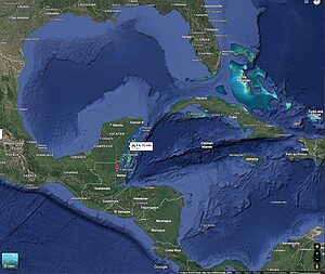
The Atlantic hurricane belt refers to the region of warm tropical waters in the Atlantic Ocean and Caribbean Sea where hurricanes most commonly form and travel. Every year from June 1 to November 30, tropical storms develop here, fed by warm sea temperatures and shifting winds.
- Peak Activity: September and October.
- Geographic Reach: Caribbean islands, Central America (including Belize), the Gulf of Mexico, and parts of the U.S. coastline.
- Key Driver: The heat of the Atlantic and Caribbean waters provides the energy for storms.
Fact: Storms that form off Africa often start small but can grow quickly as they cross the hot Atlantic. By the time they reach the Caribbean, they may have jumped two categories in just 24 hours.
Patterns in the Atlantic Hurricane Belt
| Pattern | What It Means | Impact on the Caribbean & Belize |
|---|---|---|
| More Storms, Fewer Landfalls | Storm counts are rising, but steering winds often push them out to sea. | Higher activity overall, but not every storm hits land directly. |
| Rapid Intensification | Storms strengthen quickly (Cat 1 → Cat 3+ in 24–36 hrs). | Less time to prepare, higher risk of major landfall damage. |
| Weakening Before Landfall | Dry air, cooler water, or land interaction reduce storm strength. | Yucatán, Cuba, and Honduras often act as buffers for Belize. |
| Seasonal Shifts | Storms form in different regions depending on the month. | Early: Gulf/Western Caribbean. Peak: long-track storms. Late: Western Caribbean. |
These patterns show that living in the hurricane belt doesn’t mean every storm will strike, but it does mean communities must prepare for rapid changes. For Belize and the wider Caribbean, resilience is built on knowing these cycles.
The Caribbean Hurricane Belt
Many travelers hear about the Caribbean hurricane belt — a phrase used to describe the parts of the Caribbean that are most often struck by tropical storms and hurricanes.
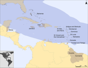
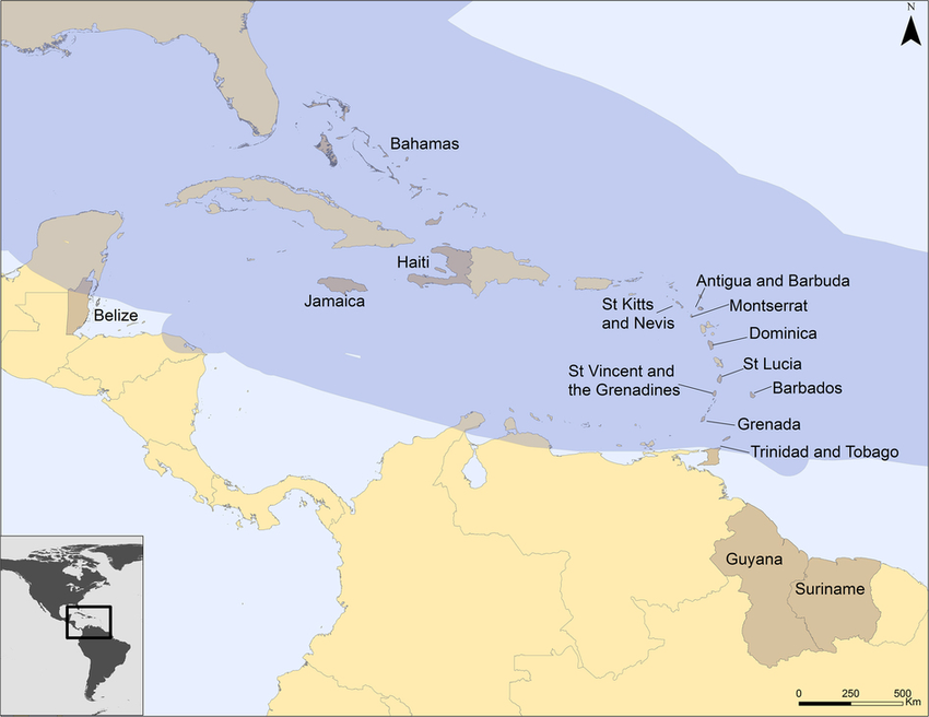
- The “Caribbean belt” generally refers to islands in the eastern Caribbean (like Dominica, St. Lucia, Puerto Rico) and the western Caribbean coastlines (including Belize, Honduras, and parts of Mexico).
- In scientific terms, this overlaps with what meteorologists call the Atlantic hurricane basin or the Main Development Region (MDR) — the warm waters between Africa and the Caribbean where most storms form.
- Belize is part of this Caribbean hurricane belt, but because of its western location, it experiences fewer direct hits than island nations to the east.
For Belizeans, “hurricane belt” is more than a geographic term — it’s a reality we’ve lived with for generations, from the 1931 Hurricane to Hurricane Earl in 2016.
| Country / Territory | Avg. Hurricane Frequency | Strongest Storm in History | Peak Risk Months | Notes for Travelers |
|---|---|---|---|---|
| Belize | Major landfall ~ every 25–30 years | Hurricane Hattie (1961, Cat 5) | Sept–Oct | Fewer direct hits than islands; barrier reef + mangroves reduce surge |
| Bahamas | Very frequent (every 2–3 years impacted) | Hurricane Dorian (2019, Cat 5) | Aug–Oct | Flat islands = very high storm surge risk |
| Cuba | Frequent (every 2–3 years impacted) | Hurricane Irma (2017, Cat 5) | Aug–Oct | Large island, varied impact by region |
| Jamaica | Occasional (direct hit ~ every 10–15 years) | Hurricane Gilbert (1988, Cat 5) | Aug–Oct | Often threatened but storms curve north |
| Dominican Republic / Haiti | Very frequent (every 2–3 years impacted) | Hurricane Jeanne (2004), Hurricane Irma (2017) | Aug–Oct | Vulnerable to floods and mudslides |
| Puerto Rico | Very frequent (every 3–5 years) | Hurricane Maria (2017, Cat 5) | Sept | Steep mountains worsen flooding |
| Lesser Antilles (e.g. Dominica, St. Lucia, Antigua) | High frequency (often first landfall zone) | Hurricane Maria (2017, Dominica) | Aug–Sept | “Front line” of the hurricane belt |
| Trinidad & Tobago | Rare (south of main belt) | Hurricane Flora (1963) | Sept–Oct | Usually spared, but heavy rain possible |
| Barbados | Occasional (direct hit ~ every 20–30 years) | Hurricane Janet (1955) | Aug–Sept | Easternmost island, first impact point |
Sources: Data compiled from NOAA Hurricane Research Division, National Hurricane Center Archives (HURDAT2), WMO, and CDEMA.
Key Takeaways
- Eastern Caribbean islands (Barbados, Dominica, Puerto Rico) are hit most often — they’re the “frontline” of the Caribbean Hurricane Belt.
- Belize and Western Caribbean coasts see fewer hits, but when storms arrive (Hattie 1961, Iris 2001, Earl 2016), they are destructive.
- Southern Caribbean (Trinidad, Grenada) is less exposed, but still part of the belt historically.
Storms that start as Category 1–2 in the eastern Caribbean often strengthen to Category 3–5 as they move west through the hurricane belt.
How the Atlantic Current Shapes the Hurricane Belt
The Atlantic Ocean current (AMOC) acts like a giant conveyor belt, moving warm water north and cold water south. This flow helps control where hurricanes form and how strong they become.
- A weaker current could mean hotter waters in the tropics — giving storms more fuel.
- Storm tracks could shift further west, putting Belize and the western Caribbean more often in the path.
- Even if hurricanes don’t become more frequent, they may grow more intense.
For Belize, that means the Atlantic current isn’t just distant science — it’s directly connected to the strength of our hurricane belt and the storms we prepare for every year.
🌪️ Hurricane Alley and the Countries Most at Risk
Hurricane Alley refers to the stretch of warm Atlantic waters where most tropical storms form and intensify before moving west. The countries most often in the crosshairs are the islands of the eastern and northern Caribbean — places like Puerto Rico, the Dominican Republic, Haiti, Jamaica, The Bahamas, and Cuba.
By the time storms travel further west, many have already made landfall or lost strength. That’s why Belize, sitting at the far western edge of the Caribbean, sees fewer direct hits than these islands — though when a system does arrive, it can still be destructive.
Where Belize Fits in the Belt
Belize sits on the western edge of the Caribbean Sea, facing the Gulf of Honduras. This position means:
- Many hurricanes weaken or curve north before reaching Belize.
- Belize averages fewer direct hits than island nations like Cuba, Jamaica, or Puerto Rico.
- When storms do make landfall, they often come from the east or southeast, striking coastal towns and cayes first.
In short: Belize is in the belt, but not in its most active corridor.
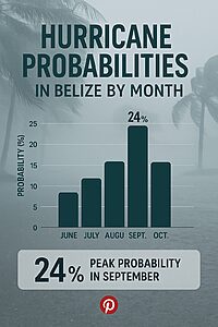
Hurricane Season in Belize
- Season Dates: June 1 – November 30.
- Peak Risk: September and October.
- Travel Impact: Most visitors still come safely during this time; many storms pass without affecting Belize.
- Preparedness: Resorts, guides, and communities follow evacuation and safety plans during storm warnings.
Historical Hurricanes in Belize
Hurricanes have shaped Belize’s history:
- 1931 Hurricane — devastated Belize City, prompting the capital’s eventual move to Belmopan.
- Hurricane Hattie (1961) — struck near Belize City with catastrophic damage; Belmopan was founded afterward.
- Hurricane Iris (2001) — hit southern Belize near Placencia, damaging homes and reefs.
- Hurricane Earl (2016) — came ashore near Belize City, causing flooding and wind damage.
Each storm left scars, but also showed Belize’s resilience and ability to adapt.
Natural Defenses
Belize is fortunate to have natural buffers:
- Barrier Reef: The second-largest in the world, breaking storm surges before they reach shore.
- Mangroves: Acting as shock absorbers, reducing flooding and protecting wildlife.
- Maya Mountains: Influencing rainfall and slowing inland storm progression.
These ecosystems aren’t just beautiful — they are part of Belize’s protection against the hurricane belt.
Belize vs Other Parts of the Belt
- Belize: Fewer direct hits, but vulnerable when storms come ashore.
- Caribbean Islands: More frequent exposure; often first landfall for Atlantic storms.
- Gulf States (Texas, Louisiana, Florida): High risk due to warm Gulf waters that fuel rapid storm intensification.
Belize’s advantage lies in its location and natural defenses, but we share the same Atlantic system as our neighbors.
Climate Change and the Hurricane Belt
Climate change is shifting the patterns of the hurricane belt:
- Stronger Storms: Warmer seas mean storms can intensify quickly.
- Rainfall Extremes: Heavier bursts of rain increase flood risk.
- Sea Level Rise: Raises storm surge potential, threatening cayes and coastal towns.
Belize is responding through conservation — protecting forests, mangroves, and reefs as climate shields — and through community preparedness.
Family Memories of Hurricanes in Belize
Hurricanes in Belize are not just statistics — they are part of family memory. I remember sitting with my grandmother as she listened to the radio. Her brother, Rene Villanueva, was one of the voices she trusted most. Back then, the radio was our lifeline during hurricane season.
The announcers would give out coordinates of the storm — numbers I didn’t understand as a child. But my grandma did. She would listen carefully, then say: “It’s not in the sixteens yet” — meaning the latitude wasn’t aiming at Belize, and more specifically not at Placencia. She didn’t need a map; she could imagine the storm’s path in her head.
If the reports showed it would stay on course, even before Phase 1 alerts, she would say: “It’s time to start prepare.”
That habit carried forward. My mom does the same thing today, but with modern tools. Instead of just the radio, we now follow updates online — even tuning into the Mr. Weatherman channel on YouTube for detailed forecasts.
For us, hurricanes have always been a mix of science, tradition, and family wisdom. It shows how Belizeans have learned to live with the Atlantic hurricane belt — not in fear, but in readiness.
Why Travelers Should Care
Understanding Belize’s place in the Atlantic hurricane belt isn’t about fear — it’s about context:
- Travel Safely: Hurricanes are seasonal and predictable; you can plan around the peak months.
- Support Resilience: By visiting Belize, you support conservation projects that protect natural defenses.
- See the Bigger Picture: Belize’s climate is tied to global systems. When the Atlantic warms, we feel it here in the reef, rivers, and rain.