The Caribbean Hurricane Season
Hurricanes Are Part of Caribbean Life
Hurricanes are more than a natural disaster in the Caribbean — they are part of life for the people of CARICOM and the wider region. The sea ties us together, but these storms test our strength and remind us just how resilient we are. For Belize, sitting at the far western end of the Caribbean Sea, our first fear when a storm forms is not for ourselves, but for our brothers and sisters in the Lesser Antilles.
From the moment a tropical wave drifts beyond those islands, our watch begins. With the internet and storm-tracking apps, we follow every update, hoping the system weakens before it reaches land. We worry for our fellow Caribbean people, knowing they face hurricanes more often and with greater intensity. At the same time, we prepare quietly in Belize — aware that while our coast does not see storms as frequently, we are all bound by the same Atlantic hurricane season, the same sea, and the same shared experience of resilience.
The Caribbean Hurricane Belt
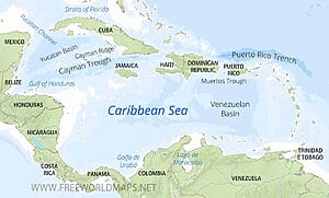
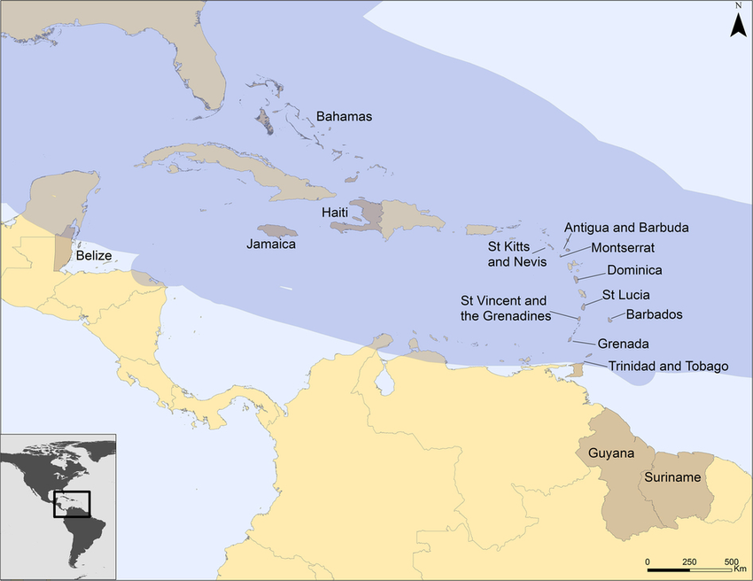
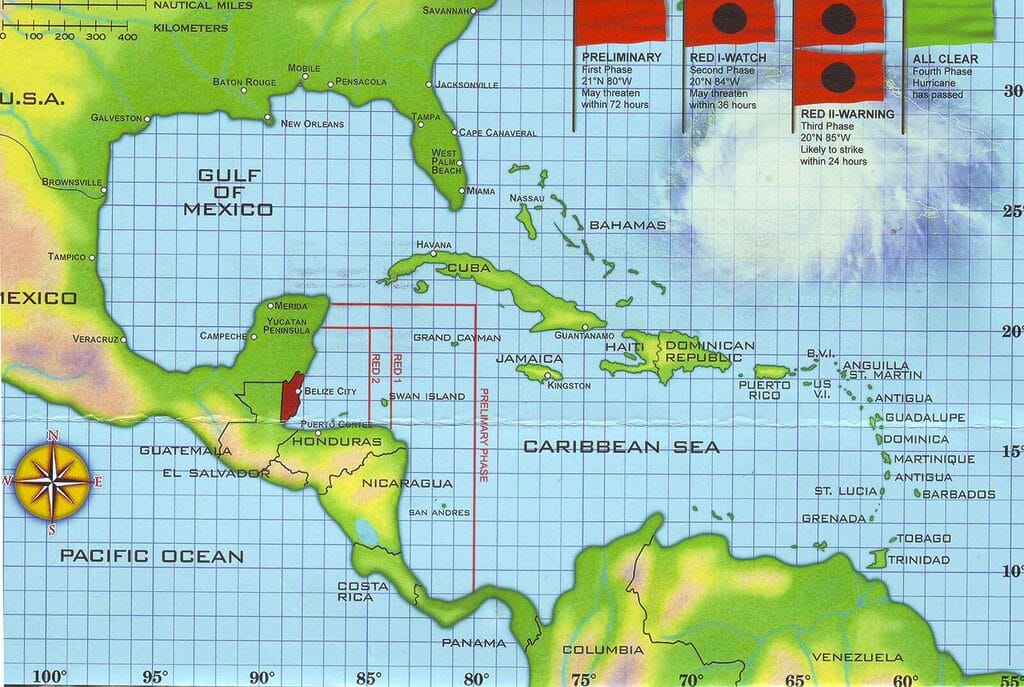
Meteorologists often describe the region as being within the “Atlantic Hurricane Belt” — a wide corridor stretching from the west coast of Africa across the Atlantic, through the Lesser Antilles, into the Caribbean Sea, and finally toward the Gulf of Mexico.
- Eastern Caribbean: Islands like Dominica, St. Lucia, Puerto Rico, and the Virgin Islands face the brunt of early-season hurricanes.
- Central Caribbean: Jamaica, Cuba, and Hispaniola (Haiti & Dominican Republic) often see the strongest storms in mid-season.
- Western Caribbean: Belize, Honduras, and the Yucatán Peninsula usually face hurricanes later in the season, when storms curve westward.
This belt explains why Belize, while less frequently hit, still lies in a zone of risk — especially from September through November, when storms that survive the journey west can make landfall on our shores.
Fact: The deadliest Atlantic storm ever recorded struck the Lesser Antilles in 1780, killing over 20,000 people. It’s a reminder that small islands face the full force of the hurricane belt
When Is Peak Hurricane Season?
The peak of hurricane season in the Caribbean is August, September, and October, with September 10 as the statistical high point. Warm waters and favorable winds make these months the most dangerous for the entire region.
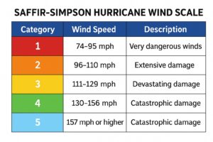
Hurricanes are ranked from Category 1–5 on the Saffir–Simpson scale, based on wind speed. But in the Caribbean, size and rainfall often cause more damage than the number alone
Atlantic vs. Caribbean Hurricane Season: Are They the Same?
Many people ask if the Caribbean hurricane season is different from the Atlantic hurricane season. The truth is: they are the same.
- The Atlantic hurricane season officially runs June 1 to November 30 each year.
- This season includes storms that can form anywhere in the Atlantic Ocean, Gulf of Mexico, and the Caribbean Sea.
- When people say “Caribbean hurricane season,” they’re usually talking about the same timeframe, but focusing on storms that impact the Caribbean islands and coasts — including Belize.
👉 In short: Atlantic hurricane season = Caribbean hurricane season (just a broader geographic term).
📊 Caribbean Hurricane Risk by Month
| Month | Most Affected Areas | Risk Level (General) |
|---|---|---|
| June | Gulf of Mexico, Western Caribbean (Belize, Mexico, Cuba) | Low–Moderate |
| July | Lesser Antilles, Puerto Rico, Hispaniola | Moderate |
| August | Eastern & Central Caribbean (Leeward Islands, Virgin Islands, Puerto Rico, Jamaica, Cuba) | High |
| September | Whole Caribbean (peak season, especially Lesser Antilles, Bahamas, Cuba, Hispaniola) | Very High |
| October | Western Caribbean (Belize, Honduras, Nicaragua, Cayman Islands, Jamaica) | High |
| November | Western Caribbean (Belize, Honduras, Cuba, southern Bahamas) | Moderate |
| December–May | Rare, but off-season storms possible | Very Low |
🌎 Risk Patterns by Region (% Approximation)
| Region / Country | % of Atlantic Basin Storm Landfalls | Notes |
|---|---|---|
| Bahamas & Turks/Caicos | ~10% | Very exposed due to position. |
| Cuba | ~9% | Large island, hit from multiple angles. |
| Dominican Republic / Haiti | ~8% | Often impacted by storms curving north. |
| Puerto Rico | ~7% | Frequently brushed or directly hit. |
| Jamaica | ~6% | Central location in storm paths. |
| Lesser Antilles (Barbuda, Dominica, etc.) | ~7% | First point of impact for many storms. |
| Belize | ~3% | Fewer direct hits, mostly late season (Oct–Nov). |
| Honduras / Nicaragua | ~5% | Late-season storms curving west. |
| Mexico (Yucatán Peninsula) | ~6% | Often hit from Gulf & Caribbean tracks. |
Belize’s Late-Season Pattern
Because of its location at the western edge of the Caribbean, Belize often experiences hurricanes later in the season compared to the eastern islands.
- October and November are particularly active for Belize.
- Hurricane Hattie (1961) struck on October 31, devastating Belize City.
- Hurricane Iris (2001) arrived on October 8, leveling parts of southern Belize.
- Hurricane Lisa (2022) struck on November 2, late in the season when many thought the danger was over.
This means travelers visiting Belize in September to November should be more alert, while those coming in June–July face far less risk.
Shared Caribbean Resilience
For those of us who grew up in Belize, hurricanes are not abstract forecasts. My grandmother listened to storm coordinates on the radio. My mother watches YouTube forecasts. And I track the rivers that rise and fall with each storm. This is how we live with the sea.
What I’ve always admired is how Caribbean people respond. In the Lesser Antilles, the Bahamas, Jamaica, Belize, and across the region, hurricanes test us — but they also unite us. Relief supplies move between islands. Governments share expertise. And communities rebuild, stronger than before. Hurricanes may divide us by geography, but they unite us in resilience.
What Travelers Should Know
If you’re planning a trip during hurricane season in the Caribbean:
- Know the season: June–November, with the peak in August–October.
- Late activity in Belize: October–November is when storms most often affect us.
- Watch the forecasts: Apps like Windy, NOAA, or local meteorological services give accurate updates.
- Flexible plans: Resorts and tour operators in Belize are experienced in moving visitors inland or adjusting itineraries if a storm approaches.
- Inland safety: San Ignacio, for example, is a common safe location when coastal resorts temporarily relocate guests.
Most storms will never touch Belize during your visit. But the key is awareness — not fear.
The Caribbean Hurricane Warning Flags
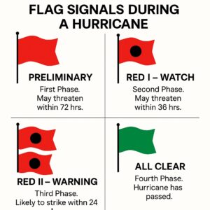
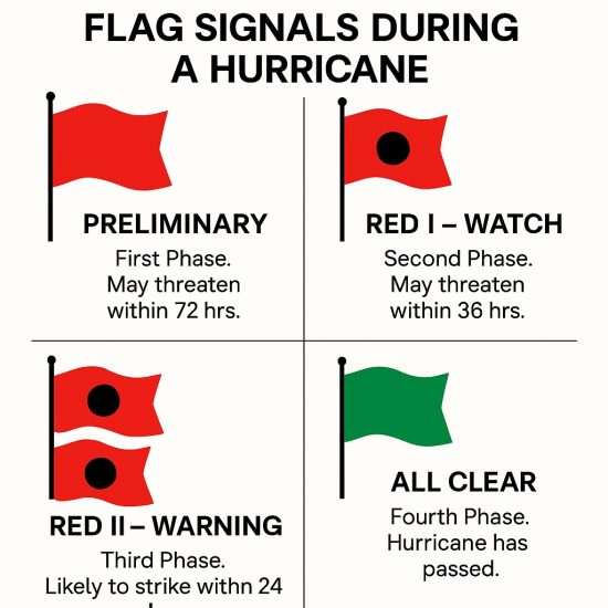
Across the Caribbean, hurricanes are tracked using a four-phase flag system that every island and coastal community understands:
- Preliminary [Red flag] – First Phase. A storm may threaten within 72 hours. This is when families begin to secure supplies and track the storm’s progress.
- Red I – Watch [Red flag with black dot] – Second Phase. A hurricane may threaten within 36 hours. Travel advisories begin, and governments prepare for possible impact.
- Red II – Warning [Two red flags with black disks] – Third Phase. A hurricane is likely to strike within 24 hours. Evacuations are ordered in vulnerable areas.
- All Clear [Green flag] – Fourth Phase. The hurricane has passed. Recovery begins, though flooding and damage may remain.
For travelers, this system shows how all Caribbean nations share the same language of preparedness. Whether you’re in Puerto Rico, Jamaica, or Belize, the meaning of each flag is the same.
Belize in the Wider Caribbean Story
Belize may sit at the far west of the Caribbean Sea, but hurricane season reminds us that we are connected to every island and shoreline touched by this great body of water. Our first concern is always for the safety of others, because we know what it feels like when the winds shift our way.
Hurricanes are part of our story as Belizeans, but so is resilience. From the way our ancestors rebuilt after Hattie in 1961, to the quiet routines of today — boarding windows, listening to forecasts, and moving inland when needed — we carry this strength forward.
For travelers, this is the deeper truth: the Caribbean isn’t just a place of sun and beaches. It’s a place of survival, of shared humanity, and of communities that know how to face the storms together.
