Belize Map – See Where It All Connects
Where is Belize, really?
That question might seem simple — but it opens the door to one of the most surprising stories in Central America.
Some people think we’re an island. Others guess we’re in South America. Some travelers stumble on Belize while researching the Caribbean — and wonder why the road signs say “Welcome to Central America.”
Let me show you on the map — and more importantly, let me explain what the map can’t say.
Belize on the World Map
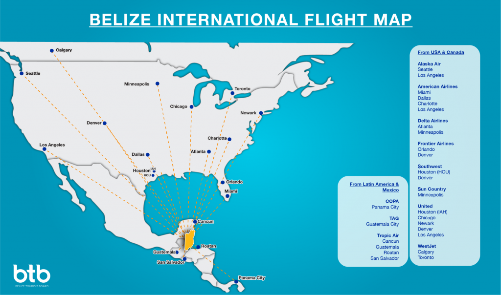
Belize is on the eastern edge of Central America, just south of Mexico and east of Guatemala. We face the Caribbean Sea, and from Belize City it’s just a couple of hours by plane to Houston, Miami, or Panama City.
We’re the only English-speaking country in Central America, and we’ve got more Caribbean cultural ties than most people realize.
That’s what makes Belize different:
We’re Central American in geography, Caribbean in soul, and Maya in memory.
Map of Belize and Surrounding Countries
Belize is bordered by:
- Mexico to the north (border town: Santa Elena / Subteniente López)
- Guatemala to the west and south (main crossing: Melchor de Mencos / Benque Viejo)
- The Caribbean Sea to the east
We’re small — about the size of Massachusetts — but what’s packed into this little space is unlike anywhere else.
Some travelers cross from Cancun to Belize by road. Others drive in from Flores, Guatemala after visiting Tikal. But once you’re in Belize, the pace changes. The journey slows. That’s how we like it.
🗺️ See Belize the Way I Know It
This is not a brochure map.
It’s a living guide to the Belize I walk, paddle, and remember.
Each marker below leads to a real story — a Maya site, a riverside moment, a hidden village, or a post that explains something most travelers miss. You won’t find resort ads here. Just places that matter.
I’ve grouped the icons so you can find what you’re curious about:
- Maya Ruins – our ancient sites and sacred places
- Info Posts – cultural insight, safety tips, and background
- Destinations – inland towns, rivers, villages, cayes
- Experience Posts – stories and reflections from the field
Click any point to start exploring Belize through my eyes.
And if something calls to you — walk with me. I’ll show you the rest in person.
Questions People Ask About Belize Maps
On the eastern coast of Central America, south of Mexico, east of Guatemala.
No — Belize is in Central America.
Yes — Belize is a Caribbean nation, especially culturally.
Yes — through the northern border near Chetumal.
One that shows more than just resorts and cayes. The best map includes rivers, villages, Maya sites, and roads inland. That’s the map I follow.
The Map Doesn’t Change — But the Seasons Do
Belize may look small on the map, but time moves differently here.
In the dry season (roughly January to May), the rivers run clear and low, and inland roads are easier to travel. In the rainy season (June through November), especially around August and again in late fall, some areas may flood or become muddy — but the forest comes alive.
If you’re planning a route, it helps to know when the rain might change your path — or when a mango tree might be full along the way.
The map can show you where Belize is — but not what it means.
Every dot you see here is more than a destination. It’s a memory. A story. A place I’ve walked or paddled or shared with someone who came to see more than the brochures.
Maps can’t guide you through feeling. But they can help you begin.
So take your time. Follow what calls to you.
And if one of these places tugs at your curiosity — walk with me. I’ll show you the rest.
belizewithalvin.com
Explore Belize
- Things To Do & See
- Popular Destination
- About the Country
Belize Map
Categories

Alvin Brown
© 2025 Belize With Alvin, all rights reserved.
Please attribute and link back to BelizeWithAlvin.com if you use any information or content from this site. Unauthorized copying or redistribution without permission is prohibited.
Privacy -:- Terms -:- Disclaimer -:- Sitemap