Where to Go in Belize: A Journey by Land, Sea, and Feeling
This isn’t just a list of places.
It’s a way of seeing Belize — through memory, rhythm, and the land itself.
🪶 INTRO: Walk With Me Through Belize
Where you choose to go in Belize matters.
Not just because of what’s there — but because of what you’ll feel when you’re there.
Some travelers rush to the islands. Others seek jungle. Some just want to unplug.
But the truth is:
Belize isn’t one place. It’s a layered memory.
A reef that breathes. A river that remembers. A mountain that carries the past in its stones.
This is not a top 10 list. This is a living map — one I’ve walked with my own two feet.
📍 Belize: Where Land Meets Sea, and Stories Take Root
Belize’s location is just right to have both a Central American visit with a Caribbean atmosphere.
Tucked between Mexico, Guatemala, and the Caribbean Sea, it’s the only English-speaking country in Central America — and yet it moves to a rhythm that’s entirely its own.
Here, jungle and reef are just hours apart.
Mountains rise inland while coral gardens bloom offshore.
Maya ruins sit quietly in the forest, while sea breeze villages hum with life.
This in-between place is what makes Belize special — and why where you go matters so much.
🗺️ MAP OF BELIZE
Explore Belize by Region and Resonance
- 🏞️ Mountain Echoes: Cayo, Maya Mountains, ATM Cave
- 🌊 Coastal Calm: Placencia, Hopkins, South Water Caye
- 🌿 Ancient Breath: Caracol, Xunantunich, Lamanai
- 🐟 Sea of Wonder: Blue Hole, Barrier Reef, Turneffe
- 🌅 Still Corners: Toledo, Orange Walk, Sarteneja
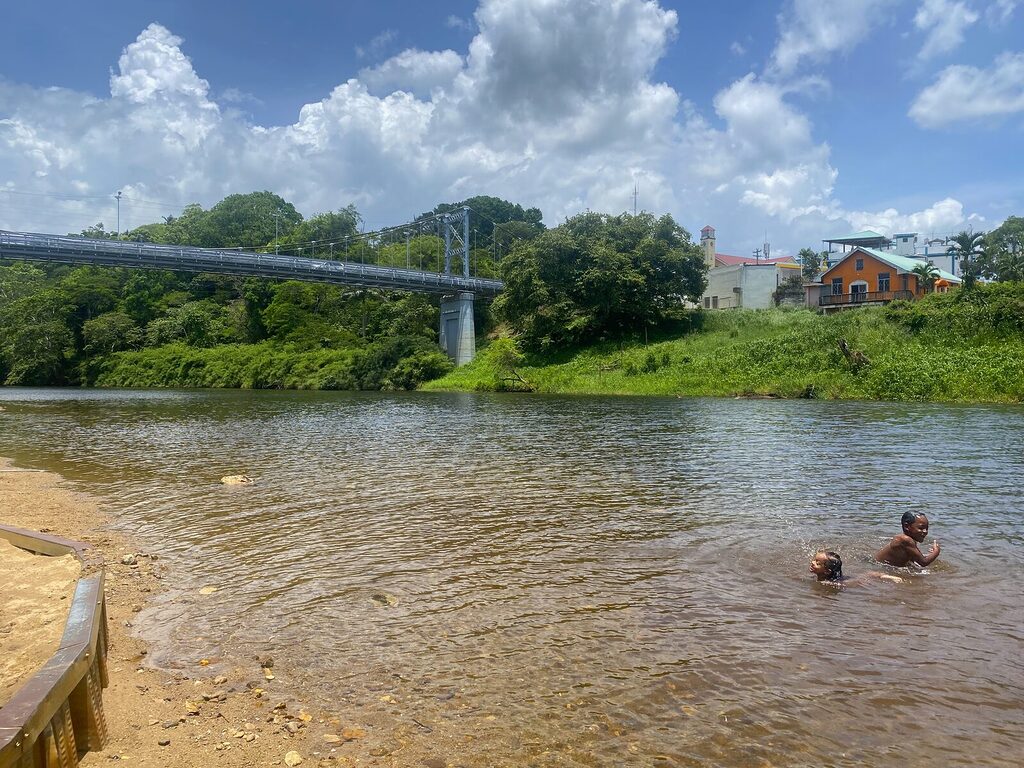
🏞️ WESTERN BELIZE — Caves, Rivers, and Ruins
This is where the forest feels ancient and alive.
Where the Macal River winds through villages, and the Maya Mountains hold mist in the mornings.
I was born by the sea — but it’s here, in Cayo, that I found my grounding.
Highlights:
- Xunantunich: A Maya site on a hill, just across a hand-cranked ferry.
- ATM Cave: One of the most sacred places in Belize — not for sightseeing, but for reverence.
- Maya Mountains: The spine of Belize, full of waterfalls, pine forests, and ancestral memory.
- Macal River: Canoeable at dawn. Calm enough to reflect the clouds.
📍Best for: Explorers, cultural travelers, nature lovers
🗓️ Best time: Dry season (Feb–May) for easy access; rainy season (Jun–Nov) is lusher, but some trails flood
🔐 Safety tip: Stick with guides for caves and ruins. Forest paths shift in rainy season.
🔗 Learn more: [The Maya Mountains: A Living Backbone] | [Is Belize Safe?] | [Belize Weather by Month]
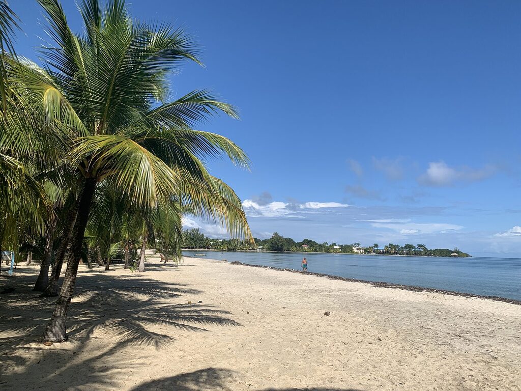
🐚 THE COAST & ISLANDS — Reef, Rhythm, and Sea Air
Belize’s Caribbean coast is where many travelers land first. But the experience changes with each shoreline.
🌀 The Great Blue Hole
🏝️ Caye Caulker vs San Pedro
Caye Caulker says, “Go slow.”
San Pedro says, “Go now.”
Both are beautiful. But know what you want before choosing. One’s a party, the other’s a pause.
📍Best for: Divers, sea-lovers, light travelers
🗓️ Best time: March–June (calm seas); August–Oct (hurricane watch, but low crowds)
🔐 Safety tip: Be reef-responsible. Avoid flipflop boats. Look for reef-safe sunscreen and proper waste disposal.
🔗 Learn More: [Barrier Reef Tours] | [Why San Pedro Isn’t For Everyone] | [The Islands Beyond the Brochures]
🌴 SOUTHERN BELIZE — Culture, Forest, and Slower Clocks
Down here, Belize breathes deeper.
Garifuna drumming in Hopkins. Cacao farms in Toledo. Ruins tucked into forest mist.
This is the most under-visited region — and maybe the most rewarding.
Highlights:
- Nim Li Punit & Lubaantun: Maya sites with stone stelae and stories in every groove
- Hopkins: A coastal village full of rhythm, food, and Garifuna heritage
- Placencia: Calm beach mornings, sand between your toes, and boat rides to the reef
📍Best for: Culture seekers, quiet nature travel, cacao lovers
🗓️ Best time: Year-round (rains come gently); September offers cultural festivals
🔐 Safety tip: Inland roads can be rough in rainy months. Ask locals for latest conditions.
🔗 Learn more: [Garifuna Culture in Belize] | [Placencia: Where Calm Meets Sea]
🌾 NORTHERN BELIZE — Quiet Routes, Deep Roots
Up north, things slow down — and the stories run deep.
You’ll find Mennonite farms, Maya ruins, and lagoons where birds fish at dusk.
- Lamanai: A river journey into the jungle, ending at towering temples
- Corozal: A coastal town near Mexico, where cultures blend
- Sarteneja: A sleepy fishing village on the edge of nowhere — and that’s the charm
📍Best for: Independent travelers, history buffs, those crossing from Mexico
🗓️ Best time: Dry season for river travel
🔐 Safety tip: Border town scams are rare but possible. Don’t accept unofficial offers to skip immigration.
🔗 Learn more: [Bus from Cancun to Belize] | [Crossing the Border Safely]
🔄 HOW TO CHOOSE WHERE TO GO IN BELIZE
This isn’t about ticking boxes. It’s about listening to what you need.
| If you feel like… | Go here… |
|---|---|
| You need peace | Placencia or Cayo |
| You want adventure | ATM Cave, Blue Hole, Mountain Pine Ridge |
| You’re drawn to ancient stories | Caracol, Lamanai, Maya Mountains |
| You want to reconnect | Macal River, South Water Caye, Toledo |
| You need a base to explore | San Ignacio or Hopkins |
🧭 Start where the feeling points. Belize will meet you halfway.
🛡️ SAFETY THROUGH PLACE AND SEASON
Belize is safe if you move with awareness, not fear.
Each destination has its rhythm — and its reminders.
- Cayo / Inland: Safe, rural, locals know each other. Caution in remote forest trails.
- Islands: Watch for boat quality, petty theft at night in party areas.
- South: Very safe, very welcoming — but cell service can drop.
- North: Caution around unofficial border “fixers.” Use only official crossings.
🔗 ↔️ [Is Belize Safe?] | [Belize Travel Safety Tips] | [Seasonal Weather and Natural Hazards]
🧳 Quick Tourist Facts About Belize
If you’re just starting to look into Belize, here are some essentials that help make sense of the place:
- 🗣️ Language: English is the official language. Most Belizeans also speak Creole (Kriol), Spanish, and indigenous languages like Q’eqchi’ and Mopan.
- 💵 Currency: Belize Dollar (BZD), fixed at 2 BZD = 1 USD. US dollars are widely accepted — no need to exchange unless you want small bills.
- 🌎 Size: Small but diverse — 8,867 square miles (about the size of Massachusetts or Wales). You can cross the country in a day, but you won’t want to.
- 🌦️ Weather: Tropical. Dry season = Feb to May, Rainy season = June to November. Hurricane season peaks around August to October.
- 🧭 Location: Eastern edge of Central America, bordering Mexico, Guatemala, and the Caribbean Sea.
- 🧬 Biodiversity: Belize protects over 60% of its forest and marine ecosystems. Home to jaguars, howler monkeys, hundreds of bird species, and the world’s first Jaguar Preserve.
- 📶 Connectivity: Cell service is strong near towns, patchy in remote areas. Wi-Fi is common in hotels. Digicell and Smart are the two main providers.
- 🛃 Entry Requirements: Most visitors get a 30-day visa-free stamp on arrival (USA, Canada, UK, EU). No COVID-19 test required (as of 2025).
- 🚗 Transportation: No Uber. Buses connect towns. Car rentals available. Local flights by Tropic Air and Maya Island Air. Private transfers like [mine] offer custom routes.
- 🧭 Time Zone: GMT -6, same as U.S. Central Standard Time (CST). No daylight saving time.
✨ READY TO WALK THROUGH BELIZE?
This is just the beginning.
You don’t have to plan it all now. Just feel which direction pulls you.
Then:
🔗 Walk With Me — and I’ll show you the rest.