Caracol Maya Ruins, Belize: Ancient Grandeur in the Heart of the Jungle
Explore the Caracol Maya ruins in Belize: uncover its rulers, astronomy, architecture, and modern-day tour experience. A majestic site steeped in mystery and power.
🏛️ The Legacy of Caracol
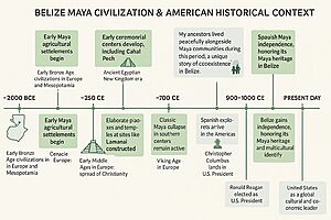
Hidden deep within the Chiquibul Forest Reserve, Caracol (“Snail” in Spanish, named after winding roads) is Belize’s largest known Maya city. Once rivaling Tikal in power, it spanned over 70 square miles and boasted a population of over 100,000 at its peak. Discovered in 1937 by a logger, Caracol continues to be excavated today.
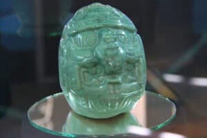
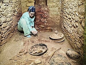
Caracol has spoken again. July 10, 2025, a new tomb was revealed… Read what this means
Quick Facts
- Time Period: Classic Period (approx. 600–900 AD)
- Travel Time from San Ignacio: ~2.5 to 3 hours (via Mountain Pine Ridge)
- Entrance Fee: BZ$15 (subject to change)
- Best Time to Visit: Dry season (Feb–May)
- Crowds: Light; remote location keeps numbers low
- Public Transport Access: None; private tour or vehicle required
👑 Rulers and Political Significance
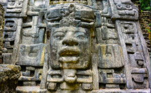
Caracol was ruled by a powerful dynasty, with Lord Kan I and Lord K’an II among its most notable kings. Under their reign, Caracol conquered rivals such as Naranjo and even defeated mighty Tikal around AD 562. The city’s emblem glyph has been found across the region, signaling its widespread influence.
🔢 Math, Astronomy, and Alignment
Caracol showcases the Maya’s advanced understanding of mathematics and celestial cycles. Buildings are aligned with solstices, and monuments include calendar inscriptions. Archaeologists discovered hieroglyphic texts that correlate with lunar cycles and historical events, affirming the Maya’s skill in recording time and astrology.
📆 Calendar and Ceremonial Timing
Many of Caracol’s monuments are inscribed with Long Count calendar dates, especially marking katun endings—20-year periods important in Maya ceremonial life. These dates often coincide with royal accessions, battles, and dedications. The Maya believed time was cyclical, and Caracol’s rulers likely used these moments to reinforce their power through rituals, offerings, and monument building.
Fun Fact: One altar at Caracol commemorates a katun-ending with astronomical references to Venus and lunar phases—revealing the spiritual and political weight these time markers held.
This cyclical worldview helped structure festivals and elite ceremonies, transforming the entire city into a time-aligned sacred space.
Learn more about the Calendar of the Mayas
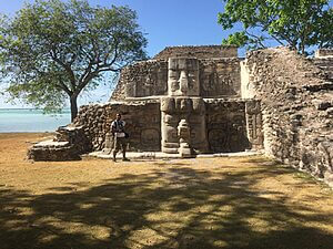
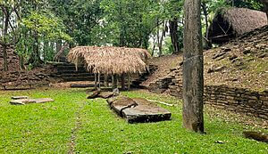
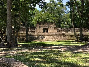
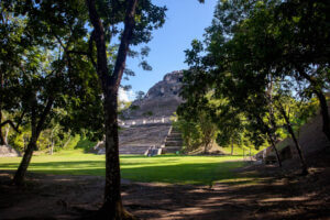
🏗️ Architecture and Urban Layout
The site includes:
- Caana (Sky Palace): Belize’s tallest man-made structure
- Plazas, causeways (sacbeob), ball courts
- Residential compounds and elite tombs
The Caana rises over 140 feet and is still climbable. It held royal residences, ritual chambers, and observation points. Caracol’s road system linked distant parts of the city and may have connected to other sites.
🔗 Relationship to Other Maya Sites
Caracol had strong ties to Tikal, Naranjo, and possibly Calakmul. It likely shared ceremonial connections via trade and elite marriages. The site’s geographic isolation made it both defensible and spiritual, surrounded by mountains, pine forests, and sacred caves.
Some believe nearby caves, including Rio Frio Cave and others in the Chiquibul area, were used for ritual purposes by Caracol’s elite—possibly priests or astronomer-priests.
🧭 Tour Experience Today
- Access: 4WD vehicle or guided tour only
- What to Expect: Scenic mountain drive, jungle wildlife, and serene ruins
- Facilities: Ranger station, restrooms, picnic areas
Alvin’s Note: “The drive to Caracol is an adventure itself. It’s peaceful, remote, and still feels like sacred ground. On top of Caana, I always pause to take in the vast forest—it really humbles you. I’ve seen jaguar tracks and toucans on the way. One day I hope to camp nearby.”
Book a Tour to Caracol
📌 Facilities & Visitor Tips
- Hours: 8:00 AM – 4:00 PM (subject to checkpoint times)
- Access Road: Long, rugged drive (~2.5–3 hours from San Ignacio)
- Restrooms: At ranger station near entrance
- Museum: Open-air display at the entrance checkpoint
- Shaded Areas: Some, but many plazas are exposed
- Footwear: Hiking boots highly recommended
- Accessibility: Challenging due to terrain; not ideal for limited mobility
- Food: No on-site vendors—bring your own packed lunch and water
Pro Tip from Alvin: A guided tour is a must here—Caracol is big, remote, and filled with history that’s easy to miss without context.
🧍🏽♂️ Who Should Visit Caracol?
- Adventurous Travelers who enjoy off-the-beaten-path history
- Families with Teens (children under 8 may find it tiring)
- Photographers and Wildlife Enthusiasts
- Cultural Explorers interested in Maya politics, architecture, and astronomy
📍 Map
📚 Sources & Further Reading