The Maya Mountains: Where Belize Breathes, Hides, and Remembers
I first visited the Maya Mountains on a school trip. I hardly remember it — just flashes of the Cockscomb Basin, the jungle closing in, the thrill of the unknown. But I came back years later as a teenager, staying overnight near the preserve. That trip ended with me and some friends walking from Jaguar Preserve all the way to the Placencia Junction.
I didn’t know it then, but that was the start of something. Over time, I would return to these mountains again and again — not just as a traveler, but as a guide, a Belizean, and someone beginning to see how everything connects.
🏞️ These Mountains Are My Memory
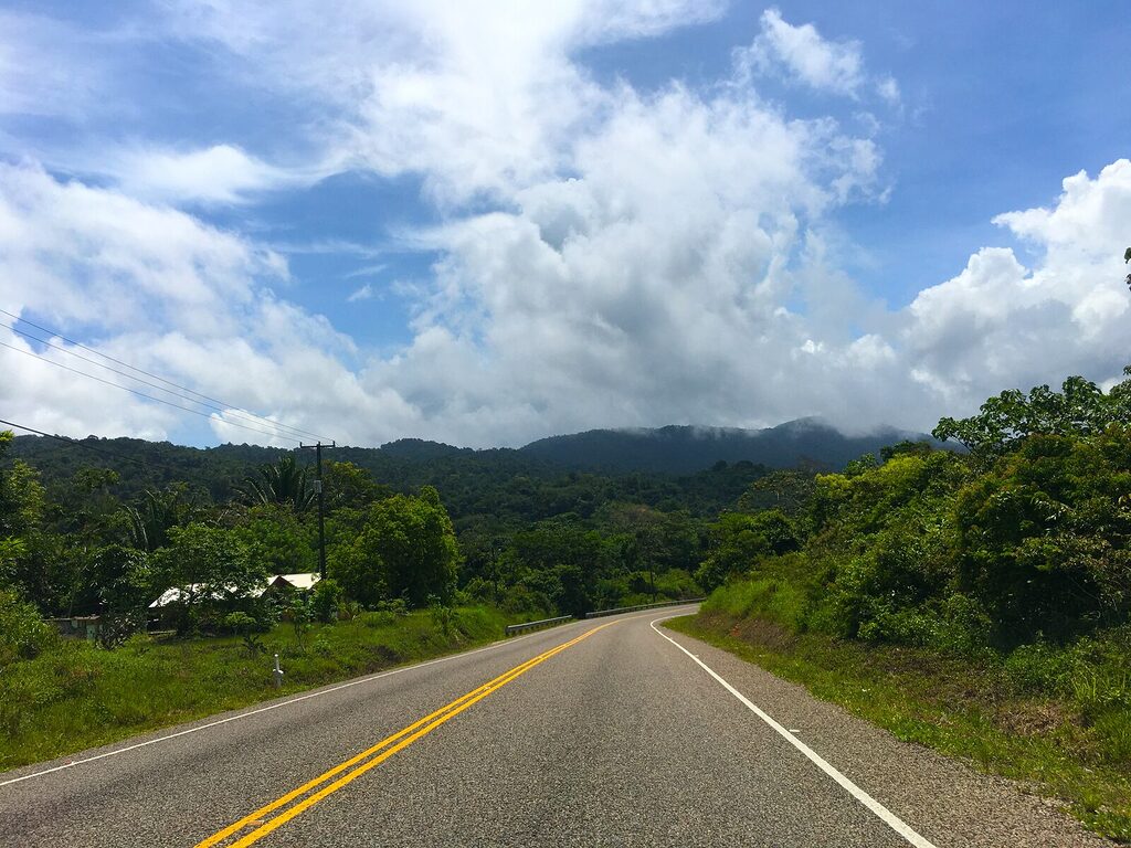
After that overnight trip, I began visiting friends in the valley communities — Steadfast, Alta Vista, Hope Creek — and sometimes my godmother in Pomona. These villages sit just outside the folds of the Maya Mountains, where orange groves once stretched like carpets beside the Hummingbird Highway.
Those trees are mostly gone now. So are many of the banana fields that once shaped the economy in the south. New ventures rise in their place, like Maya Heights, a hilltop resort that looks out toward Hopkins and the sea — giving visitors a rare view of the land and the water in one breath.
The Maya Mountains, though, haven’t gone anywhere.
👁️ I’ve Seen These Mountains From Every Angle
For four years, I saw them every morning on my way to high school. It didn’t matter how sleepy I was — the mountains were always watching, always present. You’ll catch a different view when leaving Placencia, or from Tobacco Caye, or driving to Punta Gorda. On a clear day from the south, they almost seem to float.
Even on the Caracol tour, when we stand on the ancient Maya temple Ka’ana, we’re almost on top of the ridge line — though few realize it. From the islands, people rarely notice the mountains, but from inland, they’re part of your daily horizon.
That’s how I know: these mountains are not background. They’re Belize’s spine.
🌊 From Mountains to Beaches — A Story in Sand
Here’s something I never read in a textbook — I observed it.
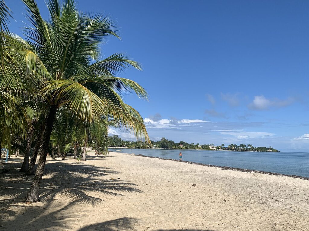
The beach sand along Placencia’s shoreline didn’t come from the reef. It came from these mountains.
Over thousands of years, rivers flowing from the Maya Mountains — like the Sittee, Monkey River, and Swasey — carried fine silt and golden sand to the coast. It settled slowly, forming the long beaches we walk on today. Unlike the coral-crushed white sand of the islands, Placencia’s sand is mountain-born.
So when you walk barefoot along Placencia’s curve, you’re touching the ancient highlands.
Years ago, David Vernon, a well-respected naturalist and guide from Placencia, said to me:
“Alvin, you’re a naturalist. You see how things fit together.”
I didn’t think much of it at the time. But now, when I look at the way mountains become rivers, and rivers become beaches, I understand what he meant.
🌳 The Maya Mountains Are More Than Scenic
They are:
- The birthplace of rivers that sustain our drinking water, agriculture, and ecosystems.
- A refuge for wildlife like jaguars, ocelots, and scarlet macaws.
- Home to ancient caves and Maya sites like Caracol and Uchbenka, still holding stories in the dark.
- The lungs and liver of Belize — filtering air, cycling rain, anchoring biodiversity.
And yet, they’re rarely mentioned by name when people book a tour. You might hear about St. Herman’s Cave, or ATM, or Nohoch Che’en, but few guides say:
“These are the Maya Mountains.”
It’s as if we’re afraid to name the body — only pointing to its parts.
🪨 The Deep Time History of the Maya Mountains
The Maya Mountains are Belize’s oldest bones — formed long before there was a Belize, a Maya, or even a Caribbean Sea as we know it.
🧱 Pre-Maya: The Foundation of the Land
The rocks that form the Maya Mountains are over 300 million years old, dating back to the Paleozoic Era. These ancient granite and quartzite formations are the oldest geologic structures in Central America.
They’re not volcanic — they’re uplifted crust. Solid, slow, and enduring. Long before the first people came, the land was already rising.
This is the spine of Belize, older than the rainforest, older than the Maya, older than the coastlines that now hug it.
🏞️ Shaped by Time, Water, and Collapse
As tectonic plates shifted and the land was pushed upward, rivers began carving deep gorges into the mountains. Over millions of years, the softer limestone surrounding the granite core dissolved, forming the vast cave systems Belize is known for today — like Actun Tunichil Muknal and Barton Creek.
These waters didn’t just erode — they shaped culture, flowing from the sacred to the everyday.
🧑🌾 When the Maya Came
The Maya didn’t build the mountains — but they listened to them.
These highlands became both a source of survival and a spiritual landscape:
- Water: The Maya relied on rivers like the Macal, Mopan, and Sittee that originate here.
- Obsidian & granite: Though rare in Belize, stone tools and construction material sometimes came from mountain foothills.
- Caves: They saw caves as portals to the underworld (Xibalba). That’s why so many Maya ceremonial sites are located in or around the mountain cave systems.
- Sacred alignment: Many Maya cities (like Caracol) were built in relation to the mountains’ position, height, and celestial alignments.
The Maya Mountains weren’t just background — they were living calendars, story-holders, and life-givers.
🛖 Postclassic and Colonial Periods
After the Maya collapse, smaller Maya groups like the Mopan and Q’eqchi’ continued to use the mountains for:
- Farming
- Hunting
- Gathering medicinal plants
- Sacred ceremonies, often deep in caves or at hidden springs
During colonial times, the mountains became a barrier — protecting inland Maya villages from Spanish reach, while also hiding runaway enslaved people and later Garifuna and Creole farmers.
To outsiders, the mountains were “wilderness.”
To those who lived here, they were refuge.
🛤️ The Logging Era
In the 1800s and early 1900s, British loggers pushed deeper into the Maya Mountains in search of mahogany and cedar.
- Logging camps scarred the forest.
- Trails and oxen roads were cut through slopes.
- Some rivers were dammed or diverted.
But even then, the mountains remained partly untamed — they were never fully conquered.
🐾 Toward Protection: The Rise of National Parks
By the 1980s and 1990s, people began to realize the Maya Mountains held more than resources — they held Belize’s ecological future.
This gave rise to:
- Cockscomb Basin Wildlife Sanctuary (world’s first jaguar preserve)
- Chiquibul National Park
- Mountain Pine Ridge Forest Reserve
- Bladen Nature Reserve
These areas now protect hundreds of species, ancient Maya ruins, and water sources that sustain the coast — even the barrier reef.
But preservation is still ongoing.
New threats — mining, road expansions, and land clearing — chip away at what the mountains give freely.
🌊 The Rivers Beneath the Ruins
Many Maya sites in Belize aren’t just built on high ground — they’re built above something deeper. Underground rivers flow beneath much of western and southern Belize, especially where the Maya Mountains begin.
These rivers carved the caves we now explore:
- ATM Cave, with its crystal chambers and sacred remains
- Nohoch Che’en, where people now float through what was once a spiritual passage
- Che Chem Ha, Barton Creek, and others — all tied to water, ritual, and movement
The Maya believed caves were portals to Xibalba, the underworld. But they didn’t pick just any cave. They chose ones where water still moved. Because to the Maya, a cave with water was a cave that was alive.
When we visit a ruin today, we often look up — but what’s beneath matters just as much. The mountains, rivers, and caves all work together. You can’t fully understand Maya sites without understanding the land’s internal flow.
🧑🏽🤝🧑🏽 People of the Mountains
Different ethnic groups in Belize have lived with and used the Maya Mountains in their own way:
- Maya communities: harvest copal, medicinal plants, and practice spiritual ceremonies in caves and riverbanks.
- Creole bushmen: gather cahoon palms, cohune oil, and medicinal bark like gumbolimbo and snake bush.
- Garifuna herbalists: venture inland for healing herbs, especially those found only in higher elevations.
- Mennonites: selectively log pinewood and farm near the foothills.
- Modern Belizeans: hike, birdwatch, and swim — whether they know it’s a mountain or not.
The Maya Mountains are still in use. Not just as scenery, but as a living resource.
🌿 A Living Pharmacy: Maya Mountains as Medicine
For generations, the Maya Mountains have been more than scenery — they’ve been a source of healing.
Villagers from places like Steadfast, Pomona, San Antonio, and even deep Toledo still walk the forest trails not just for hiking or farming, but for medicine. The mountains hold:
- Jackass bitters for cleansing the blood
- Allspice and garlic vine for colds and flu
- Gumbolimbo bark for rashes and sores
- Cohune oil for burns and hair treatment
- Rattlesnake bush, copal resin, and other plants passed down by bush doctors
Some people still know where to find the plants. Some learned from a grandmother, others from a neighbor, a healer, or just by growing up walking barefoot in the bush.
You won’t see this in brochures. But it’s a quiet truth of the mountains — they’re still providing.
And as Belize changes, these medicines are vanishing too, or becoming harder to reach. Not because they don’t grow anymore, but because roads don’t lead there, or the people who knew are gone.
To me, the Maya Mountains aren’t just a national park. They’re a living memory bank — of medicine, food, water, and story. You protect them, or you lose all of it.
The Maya Mountains connect inland forests to the sea. Track these seasonal movements in our wildlife migrations guide, from butterfly surges to coastal turtle nesting.
🚧 Development, Disruption, and Unintended Consequences
I’ve watched how progress changed the land.
When the Hummingbird Highway was upgraded, I noticed how they flattened hills and filled in dips. That sounds good for driving — but for wildlife, it broke a natural flow.
Animals no longer cross the road in certain places. They don’t feel safe. Some may never come back.
We need to replant vegetation barriers — to guide them across again, like a living invitation.
I’ve said this before too:
Monkey River Town is slowly washing away.
Not just from sea level rise — but because years ago, during upgrades, gravel and sand were taken from the Monkey River watershed. That disrupted the natural flow of sediment that used to rebuild the coast.
Now? The mouth of the river is starving.
And no one seems to want to connect those dots.
📍 Where Is This All Happening?
If you’ve only seen Belize on a map, you might imagine it as a strip of coastline or an island escape. But the Maya Mountains shift that image.
They run diagonally across western and southern Belize, anchoring the Cayo, Stann Creek, and Toledo Districts — with some of the range stretching into Guatemala.
So if you’ve ever wondered Where is Belize located?,
the Maya Mountains are part of the answer.
Not just where Belize is — but what it is.
🗺️ See this on the map
Open the Interactive Map »
📊 Fast Facts About the Maya Mountains
- The Maya Mountains are the oldest geological feature in Belize, dating back over 300 million years.
- Composed mainly of granite, quartzite, and limestone, with karst systems forming caves, sinkholes, and underground rivers.
- Home to Doyle’s Delight (1,124m) and Victoria Peak (1,120m) — Belize’s two highest elevation
- Span over 5,000 square kilometers, covering roughly one-third of mainland Belize.
- Touch Cayo, Stann Creek, Toledo, and part of the Belize-Guatemala border.
- Act as a watershed divide for nearly all of Belize’s major rivers.
- Encompass multiple ecosystems: tropical broadleaf forest, pine ridge savannas, montane cloud forest.
- Home to Belize’s largest cat: the jaguar, plus tapirs, howler monkeys, kinkajous, and the endangered scarlet macaw.
- Recently discovered species include wild avocado trees and new orchids (2025).
- A key part of the Mesoamerican Biological Corridor, connecting wildlife between countries.
Source of major river systems:
– Macal
– Mopan
– Sittee
– Monkey River
– Sibun River - Feed Belize’s coastlines with sediment that forms natural beaches like those in Placencia.
- House hundreds of caves and underground rivers, many used by the ancient Maya.
🌀 Why This Post Had to Be Written
As a guide, I’ve walked Belize’s rivers, crawled through caves, and watched clouds rise from the jungle canopy. But I’ve also built websites for other tour companies — and I noticed something strange:
The Maya Mountains are barely mentioned online.
Not by travel blogs, not by big tourism platforms, not even by many Belizean businesses.
It made me ask: Why?
Maybe it’s because they’re harder to summarize. Maybe because they stretch across districts and resist easy branding. But whatever the reason, the absence is a mistake.
If Belize is to protect what matters, we must put these mountains back in the center.
🌀 In the End, Everything Is Connected
The Maya Mountains are not just inland.
They watch the sea.
Their rivers feed the coast. Their forests filter the rain.
Their sand builds the beaches of Placencia.
Their silence gives rise to the caves and the stories we still walk through today.
So when we speak of Belize — the reef, the rainforest, the rivers, the ruins —
We must remember the backbone beneath it all.
The majestic Maya Mountains watch over the barrier reef…
And the reef, in return, protects its shores.
🧭 Walk With Me
If you’re planning a trip to Belize, I can show you these mountains — or the places they touch:
- Caracol and Mountain Pine Ridge
- Cockscomb Basin & Jaguar Preserve
- Rivers, waterfalls, and hidden trails between valleys and peaks
These aren’t just tours. They’re invitations to walk through a living memory.