🏛️ Xunantunich at a Glance
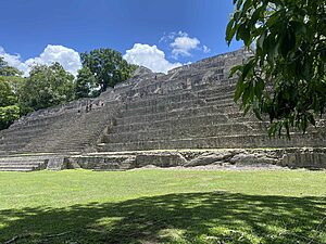
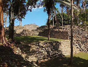
Xunantunich (pronounced shoo-nan-too-nitch) means “Stone Woman” in Yucatec Maya. It’s perched above the Mopan River near the village of San Jose Succotz in western Belize, just a short drive from San Ignacio. The site is famous for El Castillo, one of the tallest Maya structures in the country.
Quick Facts
- Height of El Castillo: Approx. 130 feet (40 meters)
- First explored: Late 1800s
- Nearby town: San Ignacio (20 minutes)
- Public transport access: Yes, via local bus and hand-cranked ferry
- Best for kids: Yes, with adult supervision
- Guided tour recommended: Highly recommended for full understanding
👑 History & Rulers
Xunantunich rose to prominence in the Late and Terminal Classic periods (c. 600–890 CE). While less is known about its early rulers compared to Caracol or Tikal, hieroglyphic inscriptions suggest strong ties to the powerful city of Naranjo (modern Guatemala). Xunantunich may have served as a regional outpost or administrative hub in the Mopan Valley.
One stela features a ruler possibly named K’an II, whose glyph appears similar to the ruler of Caracol, suggesting either shared lineage or political allegiance.

🔢 Astronomy and Alignment
El Castillo is thought to be aligned with the solstices. Its elevated position suggests that Xunantunich served not only as a ceremonial center but also as an astronomical observatory. Some scholars propose it was used to track Venus and seasonal cycles important to agriculture.
📆 Calendar and Ceremonial Timing
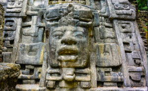
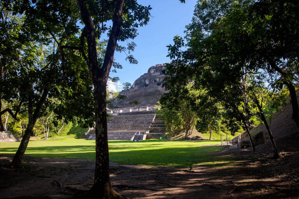
Xunantunich’s grand pyramid, El Castillo, is more than a lookout point—it’s a monument to time. The stucco frieze includes symbols of the sun, moon, and Venus, anchoring it in Maya cosmology. Stelae placed in front of the structure likely commemorated katun endings—major 20-year cycles in the Maya calendar. These public inscriptions weren’t random—they marked moments of cosmic transition, celebrated with dances, offerings, and royal pronouncements. Standing at El Castillo, you’re not just seeing history—you’re standing in a clock of stone.
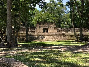
🏗️ Architecture & Layout
El Castillo, the main pyramid, stands about 130 feet tall and remains one of Belize’s tallest man-made structures. Its summit offers panoramic views of the Cayo District and even into Guatemala.
The site features:
- Ball courts
- Palatial residences
- Ceremonial plazas
- Intricate stucco friezes depicting gods and celestial elements
🔗 Relationship to Other Maya Sites
Xunantunich maintained strong cultural and political ties with:
- Naranjo (Guatemala): Possible parent site
- Caracol: Military ally or rival, depending on the era
- Cahal Pech: Located nearby, may have been subordinate or a trading partner
🧭 Today’s Relevance
Xunantunich is one of the most accessible and well-preserved Maya sites in Belize. Its proximity to San Ignacio makes it ideal for day trips, especially for families. Local guides bring its stories to life, and you can combine your visit with stops at Cahal Pech or the nearby Mopan River.
Local Maya vendors often sell handmade crafts and souvenirs at the entrance, giving you a chance to support the community. San Ignacio’s nearby San Antonio Women’s Cooperative is also a present-day example of living Maya culture—offering traditional meals, crafts, and workshops.
🧭 Tour Experience Today
You’ll start by crossing the Mopan River on a hand-cranked ferry, then make a short uphill drive or hike to the entrance. From there, trails lead through plazas, temples, and scenic viewpoints. A climb to the top of El Castillo is a must—it’s safe but steep.
🧭 Alvin’s Tip: Visit around 10 AM—by then the morning mist has lifted, the site is alive with birds, and you’ll avoid the midday heat.
📌 Facilities & Visitor Tips
- Hours: 8:00 AM – 5:00 PM daily
- Ferry Crossing: Hand-cranked ferry across the Mopan River (free)
- Restrooms: Available at entrance and museum
- Museum: Small visitor center with artifact displays
- Shaded Areas: Limited inside core site; bring a hat
- Footwear: Light hiking shoes recommended
- Accessibility: Moderate incline to El Castillo
- Food Nearby: Small shops in Succotz Village; pack water/snacks
Pro Tip from Alvin: Visit after early morning rain—toucans and howlers often appear in the trees around the main temple.
Compared to Caracol
🧍🏽♂️Who Should Visit Xunantunich?
- First-time travelers to Belize
- Families with children
- History and archaeology enthusiasts
- Photographers and nature lovers
Walk With Me. I’ll Show You My Belize.
📍 Map
🗺️ See this on the map
Open the Interactive Map »
FAQ
Lorem ipsum dolor sit amet, consectetur adipiscing elit. Ut elit tellus, luctus nec ullamcorper mattis, pulvinar dapibus leo.
📚 Sources & Further Reading
- Belize Institute of Archaeology
- Foster, Lynn V. Handbook to Life in the Ancient Maya World
- Sharer, Robert J. & Traxler, Loa P. The Ancient Maya (6th Edition)
- Awe, Jaime J. (2005). Belize’s Western Frontier